
Field AI
Paid ✓ VerifiedField AI builds autonomous mobile robots for industrial and infrastructure environments that operate reliably in unstructured, GPS-denied settings.
Screenshot coming soon
📋 About Field AI
Field AI develops autonomous robotics software and systems designed to operate in real-world industrial environments — warehouses, construction sites, utilities infrastructure, and outdoor terrain where GPS signals are unreliable or absent. The core technology is a perception and navigation stack that allows robots to map their environment in real time, avoid obstacles, and execute assigned tasks without continuous human supervision. Unlike controlled lab or warehouse automation, Field AI targets the messiest, most unpredictable physical environments where traditional robotics approaches tend to break down.
The platform is built around a sensor fusion architecture that combines LiDAR, cameras, and IMUs to maintain accurate localization even when external positioning signals are unavailable. Operators deploy the system by assigning missions through a management interface, with the robot handling all navigation and obstacle avoidance autonomously. Fleet management tools allow operators to monitor multiple units simultaneously, review mission logs, and intervene remotely when needed.
Field AI targets construction, utilities, oil and gas, and defense sectors where manual inspection and data collection in hazardous or difficult-to-access areas carries real safety and cost burdens. By replacing human workers in routine inspection loops, the platform reduces exposure to dangerous environments while increasing the frequency and consistency of data collection. Pricing is enterprise and project-based, reflecting the high-stakes deployment contexts and the customization required for specific industrial use cases.
⚡ Key Features of Field AI
GPS-Denied Autonomous Navigation
Field AI's navigation stack maintains accurate localization in environments where GPS is unavailable or unreliable, including underground tunnels, dense industrial facilities, and outdoor terrain with obstructed sky views. Sensor fusion combines LiDAR point clouds, camera feeds, and inertial measurements to produce a continuously updated map of the surrounding environment. The robot re-localizes automatically if sensor data is temporarily degraded, avoiding mission failure due to transient signal issues. This makes field ai deployable in exactly the environments where traditional autonomous vehicles struggle most.
Real-Time 3D Mapping
As the robot moves through an environment, field ai builds and updates a 3D map in real time that captures structural features, obstacles, and changes since the last mission. These maps are stored and can be compared across missions to detect changes — useful for monitoring construction progress, identifying infrastructure degradation, or tracking site modifications. The mapping data can be exported for integration with GIS platforms or engineering software. Incremental map updates mean subsequent missions in the same environment start with existing context rather than remapping from scratch.
Mission Planning Interface
Operators define missions through a management interface that supports waypoint-based path planning, area coverage patterns, and task assignments without requiring robotics programming expertise. Missions can be templated and reused across multiple units or repeated on a schedule for recurring inspection cycles. The interface provides a top-down visualization of the planned route overlaid on the existing map so operators can review and adjust paths before deployment. This reduces the technical barrier to deploying autonomous inspection robots in operational settings.
Fleet Management and Monitoring
Multiple robots can be managed simultaneously through a single dashboard that shows each unit's location, mission status, battery level, and sensor health in real time. Operators receive alerts when a robot encounters an unexpected obstacle, completes a mission, or requires intervention. Mission logs with timestamped sensor data and robot telemetry are stored for review and audit purposes. Fleet-level analytics surface utilization patterns and mission success rates across a deployment.
Remote Intervention and Teleoperation
When a robot encounters a situation it cannot resolve autonomously, operators can take direct remote control using a teleoperation interface that streams live sensor feeds from the robot's perspective. Control handoff is designed to be low-latency so the operator can navigate through unexpected conditions and return the robot to autonomous mode once the obstacle is resolved. Remote intervention logs are preserved alongside autonomous mission data to support post-incident review and model improvement.
Enterprise Integration and Data Export
Field AI is designed to slot into existing enterprise workflows by exporting inspection data, 3D maps, and mission logs in formats compatible with common industrial and GIS software. API access enables integration with asset management systems, allowing inspection findings to be automatically associated with specific assets in the operator's existing records. Custom data pipelines can be configured for deployments with specific reporting or compliance requirements.
🎯 Use Cases for Field AI
⚖️ Field AI Pros & Cons
Advantages
- ✓Operates reliably in GPS-denied and unstructured environments where most autonomous systems fail
- ✓Real-time 3D mapping provides persistent, comparable records across missions
- ✓Fleet management tools scale to multiple simultaneous deployments from a single interface
- ✓Reduces human exposure to hazardous inspection environments
Drawbacks
- ✗Enterprise pricing means it is inaccessible for small-scale or experimental deployments
- ✗Integration with existing industrial software may require custom configuration
- ✗Requires on-site setup and likely vendor support for initial deployment
- ✗Depends on adequate sensor conditions — very low-light or highly reflective environments may degrade performance
📖 How to Use Field AI
Contact Field AI through the website to discuss your specific deployment environment and use case.
Work with the Field AI team to configure the hardware and software stack for your site conditions.
Load the mission planning interface and define waypoints or coverage areas on the environment map.
Deploy the robot and monitor its progress in real time through the fleet management dashboard.
Review completed mission data including 3D maps, sensor logs, and anomaly flags in the data export tools.
Compare successive mission maps to track changes and generate inspection reports for your asset management system.
❓ Field AI FAQ
Field ai is specifically built for unstructured, GPS-denied environments — the settings that are most common in real industrial and infrastructure contexts. Most autonomous mobile robots are designed for controlled indoor warehouse environments with reliable positioning signals, which limits their usefulness in construction, utilities, and field operations.
Field ai provides an integrated hardware and software platform rather than software-only licensing. The system includes the robot hardware, sensor suite, and the navigation and management software as a combined deployment package, typically customized for each client's specific environmental requirements.
Field ai focuses on construction, utilities, oil and gas, mining, and defense — sectors where physical inspection in challenging environments represents a significant cost and safety burden. These industries have the clearest ROI case for replacing human walkers with autonomous inspection robots.
Field ai robots operate autonomously for defined missions, but the platform includes remote intervention and teleoperation capabilities for situations the robot cannot resolve on its own. Fully unsupervised operation is possible for routine missions in well-mapped environments, with human oversight available as a fallback layer.
Related to Field AI
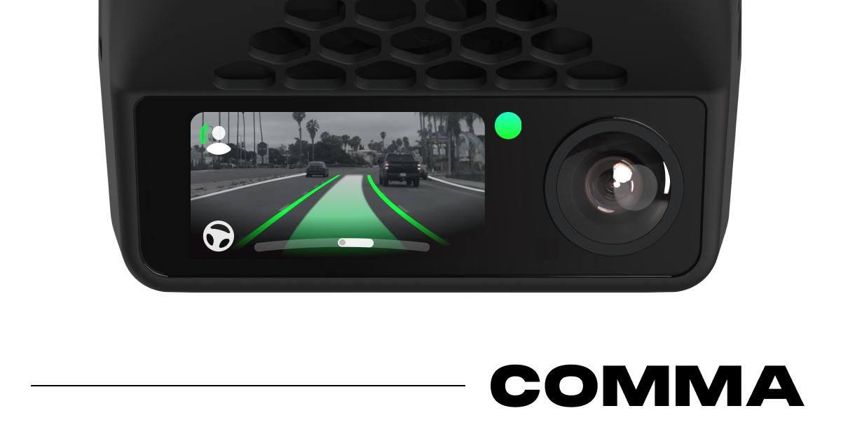
Comma AI
Comma AI open-source driver assistance system using the comma 3X device to add semi-autonomous lane centering and cruise control to compatible cars.

Fireworks AI
Fireworks AI provides fast, cost-efficient API inference for open-source LLMs and image models with fine-tuning and private deployment support.
Featured on WhatIf.ai
Add this badge to your website to show you're listed on WhatIf AI
Alternatives to Field AI


A2E AI
A2E AI productivity platform converts audio and video recordings into transcripts, summaries, and action items with speaker identification.


Abnormal AI
Abnormal AI uses behavioral AI to detect business email compromise, account takeover, and socially engineered phishing that bypasses secure email gateways.


Abridge AI
Abridge AI medical documentation platform that records and summarizes clinical conversations into structured physician notes in real time.


Air AI
Air AI conducts autonomous full-length AI phone calls for sales prospecting, appointment setting, and customer service without human agents.